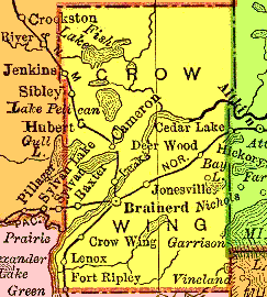
 Welcome To Crow Wing County - - 1895 Map - - |
|
This map is from the The New 11 x 14 Atlas of the World
published and copyrighted in 1895 by the Rand McNally Corporation.
It shows the towns and railroad lines in Crow Wing County, Minnesota, in 1895.
|
The map at the left is a manually processed, cleaned-up version
of the area of the State map
showing Crow Wing County. Pam Rietsch did a marvelous job at digitizing and indexing the maps from an old Atlas that was about to be discarded. Please visit her 1895 U.S. Atlas pages at the Livingston County, Michigan, USGenWeb site for more info: |
 |
<http://crowwing.mngenweb.net/mncw1895.html> | May 27, 2005 | |
|
MNGenWeb - Crow Wing County - 1895 Map Home Page | About This Site | Contact Us |
|