 Welcome To Crow Wing County - - 1914 Map - - |
|
(From the source website) This is from a book with no cover.
The name at the top says Atlas of the World.
The maps are dated 1910-1914.
|
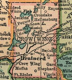
The map at the left has been extracted from the area of the
State map showing Crow Wing County. It shows the towns and railroad lines in Crow Wing County, Minnesota, in 1914. Janie Edwards did a marvelous job at digitizing the maps from an old Atlas that was found in a shed. Please visit her 1914 U.S. Atlas pages at the Shasta County, California, USGenWeb site for more info:
|
 |
<http://crowwing.mngenweb.net/mncw1914.html> | Feb 27, 2009 | |
|
MNGenWeb - Crow Wing County - 1914 Map Home Page | About This Site | Contact Us |
|