
 Welcome To Crow Wing County - - Map of Townships - - |
|
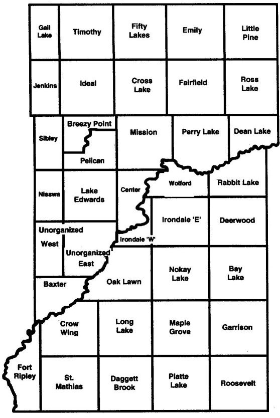
This map shows the townships in Crow Wing County, Minnesota.
See below for Township/Range numbers and other notes.
 |
|
Township and Range numbers
sorted left to right, top to bottom T138N R29W Gail Lake T138N R28W Timothy T138N R27W Fifty Lakes T138N R26W Emily T138N R25W Little Pine T137N R29W Jenkins T137N R28W Ideal T137N R27W Cross Lake T137N R26W Fairfield T137N R25W Ross Lake T136N R29W Sibley T136N R28W Breezy Point T136N R28W Pelican T136N R27W Mission T136N R26W Perry Lake T136N R25W Dean Lake T135N R29W Nisswa (City) T135N R28W Lake Edward T135N R27W Center (northern portion) T134N R27W Center (southern portion) T47N R30W Wolford (western portion) T47N R29W Wolford (eastern portion) T47N R28W Rabbit Lake T134N R29W Unorganized (western portion) T134N R28W Unorganized (eastern portion) T46N R30W Irondale (western portion) T46N R29W Irondale (eastern portion) T46N R28W Deerwood T133N R29W Baxter T45N R31W Brainerd (City) T45N R30W Oak Lawn T45N R29W Nokay Lake T45N R28W Bay Lake T44N R31W Crow Wing T44N R30W Long Lake T44N R29W Maple Grove T44N R28W Garrison T44N R32W Fort Ripley (northern portion) T43N R32W Fort Ripley (southern portion) T43N R31W St. Mathias T43N R30W Daggett Brook T43N R29W Platte Lake T43N R28W Roosevelt |
Township and Range numbers
sorted alphabetically by Township name T133N R29W Baxter T45N R28W Bay Lake T45N R31W Brainerd (City) T136N R28W Breezy Point T135N R27W Center (northern portion) T134N R27W Center (southern portion) T137N R27W Cross Lake T44N R31W Crow Wing T43N R30W Daggett Brook T136N R25W Dean Lake T46N R28W Deerwood T138N R26W Emily T137N R26W Fairfield T138N R27W Fifty Lakes T44N R32W Fort Ripley (northern portion) T43N R32W Fort Ripley (southern portion) T138N R29W Gail Lake T44N R28W Garrison T137N R28W Ideal T46N R29W Irondale (eastern portion) T46N R30W Irondale (western portion) T137N R29W Jenkins T135N R28W Lake Edward T138N R25W Little Pine T44N R30W Long Lake T44N R29W Maple Grove T136N R27W Mission T135N R29W Nisswa (City) T45N R29W Nokay Lake T45N R30W Oak Lawn T136N R28W Pelican T136N R26W Perry Lake T43N R29W Platte Lake T47N R28W Rabbit Lake T43N R28W Roosevelt T137N R25W Ross Lake T136N R29W Sibley T43N R31W St. Mathias T138N R28W Timothy T134N R28W Unorganized (eastern portion) T134N R29W Unorganized (western portion) T47N R29W Wolford (eastern portion) T47N R30W Wolford (western portion) |
The Mississippi River divides the two Township/Range numbering grids that apply to areas East and West of the Mississippi. Furthermore, some townships straddle Township/Range boundaries and thus have more than one Township/Range notation.
From the Crow Wing chapter of the book "Minnesota Place Names A Geographical Encyclopedia" by Warren Upham:
By an act of the legislature, February 18, 1887, which was ratified by the vote of the people of the county at the next general election, the part of Crow Wing County west of the Mississippi River, previously belonging to Cass County, was annexed to this county, somewhat more than doubling its former area.
So the western portion of Crow Wing county (township numbers from T133-138N) was originally part of Cass county until that date. Keep that in mind when looking for township information before 1887.
Name changes, annexations, and other historical notes:
MNDOT has 1 inch = 1 mile scale County Maps. The Crow Wing map has a Southern Half and a Northern Half.
The official Crow Wing County county map has Township names, Township/Range numbers, section numbers, and the E911 address grid. It is available from the Crow Wing County Highway Department, 202 Laurel Street, Brainerd, MN, 56401. Phone: 218-824-1110.
 |
<http://crowwing.mngenweb.net/twnshps.html> | Feb 23, 2019 | |
|
MNGenWeb - Crow Wing County - Map of Townships Home Page | About This Site | Contact Us |
|